Important Historical Maps in History
Are you looking for historical maps for your next travel? It has been part of human nature to be interested in and fascinated with the world since prehistoric times. Those paintings seen in caves and the markings on artifacts and bones that were once considered nothing but artistic representations were maps of routes, streams, hunting areas, and even the stars. This is what the latest investigations have revealed.
Table of Contents
Historical maps have played a crucial role
The oldest route ever recorded that still has solid evidence is a wall painting that stands at 9 feet. It was of a town plan discovered in 1963 that shows a volcano and buildings. It is dated 6100 to 6300 BC and found in Anatolia.
There are also known early representations of routes and maps made on papyrus by the old Egyptians. However, because this type of surface has a short life, there is not much evidence that these maps have survived to the modern day.
Maps also often become more popular than the people who made them. Most cartographers only rose to fame because of their contributions to the science and art of cartography only after they had come up with a masterpiece.
Meanwhile, those who have already become famous created equally renowned works for their time’s well-known explorers, nobility, and royalty. And then some made one famous map only to vanish from history forever.
Although the cartographers of the bygone days didn’t use the phrase location intelligence, they already had a keen awareness of the intended purpose of their maps. More often than not, this purpose was as direct as showing the dimensions of an unknown city. There are also times when it was as controversial as divulging racial violence.
Through the years, different historical maps have played a crucial role. Listed below in chronological order are some of the notable historical events in the field of mapmaking, together with some of the oldest maps in the world. These maps show that innovations in aesthetics and perspective data of a map significantly contributed to the complicated evolution of location intelligence through the centuries.
1502 “Town Plan of Imola” by Leonardo da Vinci
A general from Rome, Cesare Borgia, conquered the northern Italian city of Imola in 1499. Back then, the place was in charge of protecting the unfamiliar territory. This prompted Borgia to commission Leonardo da Vinci to create a map of the area.
Surprisingly, Da Vinci came up with something that looks somewhat familiar thanks to its use of a similar bird’s-eye perspective as the modern-day Google Maps known as ichnography. However, this technique was not easy, nor was it obvious.
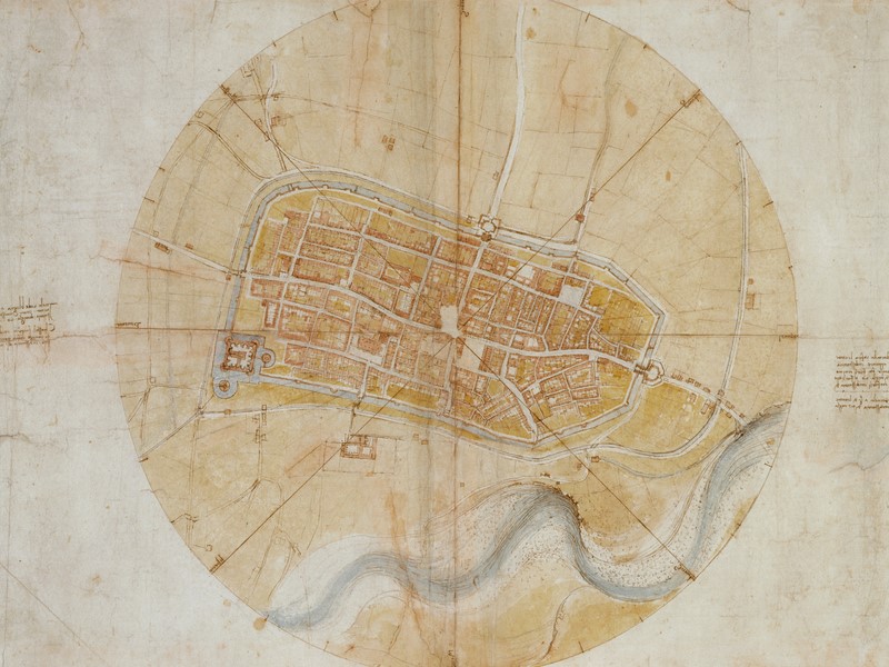
Cartographers before the time of da Vinci mainly used the so-called oblique perspective, which showed the different elevations of the city. However, da Vinci was able to correctly deduce that a flat point of view would be much better aligned with the desires of Borgia.
But since there were no aerial photos during that time, da Vinci had no choice but to rely on the meticulous measurements of each plot of land and building road. Although he made some minor distortions to some areas for aesthetic purposes, da Vinci’s map is a somewhat exact rendering of the city of Imola, making it the oldest existing record of ichnography.
1851 “Whale Chart” by Matthew Fontaine Maury
Before kerosene was invented, the preferred light production method was whale oil. Just one whaling expedition can easily net profits in millions of dollars. Sadly, it also meant the possible extermination of some of the most intelligent marine mammals in the world.
As far as location intelligence is concerned, the map that Maury made is critical as far as historical maps are concerned because of two primary reasons. First, this is an excellent early example of the method known today as crowdsourcing.
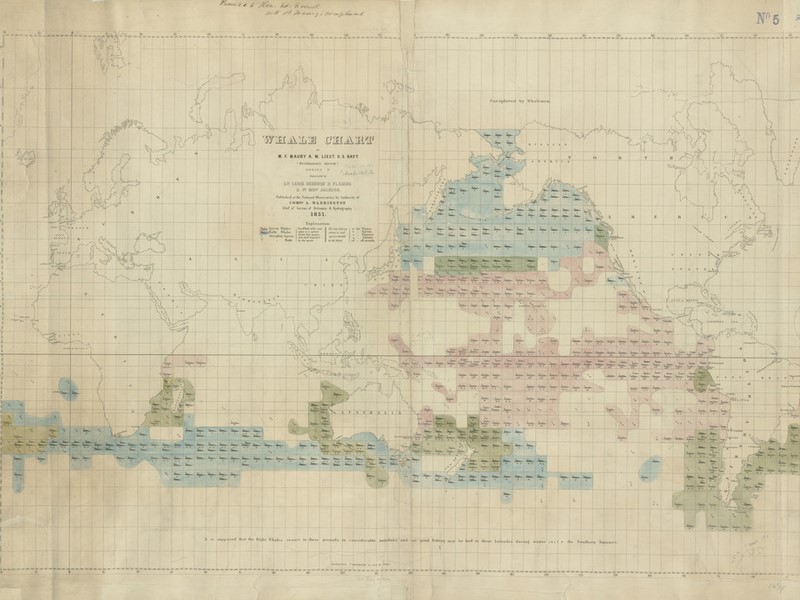
Maury developed special logbooks for tracking water temperatures and weather wind currents and gave them to the whale hunters. The whale hunters received the whale chart in exchange for their recordkeeping. One sailor referred to it as a precious jewel highly in demand among those interested in whaling.
The second reason for the importance of Maury’s map was its introduction of a new form of location intelligence. Rather than conveying data regarding fixed points, it provided something more complex and valuable. It predicted the areas where mariners are more likely to succeed.
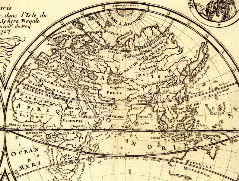
1594 “The Molucca Islands” by Petrus Plancius
Portugal was already enjoying a global maritime power during the late 16th century. The country had trade outposts on almost all continents, with Australia being the only exception. Having such a commanding fleet called for maps that boast of equal sophistication.
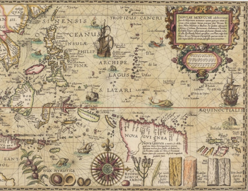
More than two decades before Plancius published his work entitled “The Molucca Islands,” Gerardus Mercator solved the issue of representing the Earth’s spherical shape on a flat surface. However, the method called for too complex calculations for most cartographers. It was the reason why it wasn’t extensively used.
The map developed by Plancius showed that he understood not just the involved mathematics but even the psychology of selling a brand-new perspective.
Using rich colors to fill empty areas with excellent drawings and reminding sailors of their commercial ambitions with the illustrations of the exotic spices, Plancius guaranteed that out of most of the historical maps available back then, his creation served as the standard.
1971 “Where Commuters Run Over Black Children on the Pointes-Downtown Track” by William Bunge
The map developed by William Bunge is a tragic and provocative culmination of the first four historical maps above. This uses a bird’s-eye perspective to provide a holistic view of the chosen area.
It reveals Detroit commuters’ navigational patterns and routes and relies on information from different sources, including police reports and resident newspapers. This map by Bunge, however, adds an implicit argument that goes beyond the depicted data.


