Remarkable Historical Maps and What They Show
Among the most interesting types of historical maps are the ones that depict wars or battles. A historical battle map shows the area where the battle took place and the area that every force occupied as well as their movement. The bigger maps of wars like the World Wars often show both sides in different colors. For instance, the countries on the Axis side will be in red while the Allied countries will be blue. These maps also often show movements of the two sides and specific locations of the key battles.
Territory maps reveal the borders of countries and states have changed through the years. United States is a good example of this. For the past 200 years, the open land turned into territories, the territories became states, and there were changes in the boundaries, too. There are also some maps with different pages you can layer, showing how things changed.
Table of Contents
8 Notable Early Maps
Here are eight of the most crucial maps that go as far back as cartography’s early history:
The Babylonian World Map
The earliest known world map in history was scratched on the clay tablets in Babylon’s ancient city maps sometime around 600 BC. This star-shaped map only measures 5 by 3 inches showing the world as flat disc surrounded by a “bitter river” or ocean. There is an accompanying cuneiform text describing the unknown lands to be occupied by mythological beasts, suggesting that the map reveals actual geographical features and Babylonian cosmology elements.
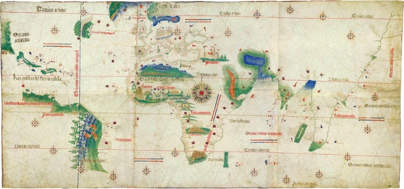
The Cantino Planisphere
Once at the center of a cartographic theft act, the Cantino Planisphere not just depicts Europe, India, and Africa in unprecedented detail because this also stands as among the earliest maps ever known that show the coastlines of the New World territories of Portugal in South America. The map also indicates a tiny grouping of landmasses to the northern part of Brazil that look like Hispaniola, Cuba, and part of American East Coast.